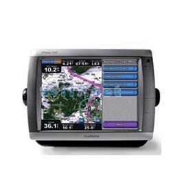
This flagship marine navigator is missing only one thing — buttons. The GPSMAP 5012 features an unprecedented touchscreen interface, along with a satellite-enhanced worldwide basemap and a massive 12" (31 cm) screen that makes navigation as easy as pointing your finger. By connecting to the Garmin Marine Network, you can add sonar, radar and weather. For even more advanced features, you can add the optional BlueChart? g2 Vision? card.
The GPSMAP 5012 features a worldwide basemap with high-quality satellite images in place of more traditional maps. For even more detail, you can add maps easily with the SD? card slot without having to connect to a computer. The 5012’s huge XGA screen displays graphics with crisp, video-quality resolution. To keep tabs on your engine room or other area of your boat, you also can connect a live video feed with the 5012's video input/output options.
With the optional BlueChart g2 Vision SD card, you can add a whole new dimension of exceptional features to your chartplotter.
MarinerEye view and FishEye view provide you a 3-D perspective of map information, both above and below the waterline.
High-resolution satellite images and aerial photographs help you orient yourself in unfamiliar areas.
Auto Guidance technology searches through all relevant charts to create a route you actually can follow — one that avoids obstacles, shallow water, buoys and other obstructions.
The 5012 connects easily to the high-speed Garmin Marine Network, so you can interface with additional MFDs and add remote sensors. Once connected, you can share information between the 5012 and other chartplotters on your boat. You also can add high-powered radar and sonar to your system.
硬件和性能: | |
| 尺寸,长x宽x高: | 13.0" x 9.5" x 4.7" (33.0 x 24.1 x 11.9 cm) |
| 显示屏尺寸,长x宽: | 9.7" x 7.3", 12.1" diagonal (24.6 x 18.4 cm, 30.7 cm diagonal) |
| 分辨率,长x宽: | 1024 x 768 pixels |
| 显示类型: | Touchscreen XGA display |
| 重量: | 9.5 lb (4.3 kg) |
| 电池: | none |
| 电池使用时间: | none |
| 防水: | 是(IPX7) |
| 高灵敏度接收机: | 有 |
| 天线: | external |
| NMEA输入/输出: | NMEA 0183, NMEA 2000 |
地图和内存: | |
| 电子底图: | 有 |
| Preloaded maps: | 无 |
| 可附加地图: | 有 |
| 内存: | none (cannot load maps to internal memory) |
| 支持存储卡: | SD? card slot (BlueChart g2 Vision cards sold separately) |
| 航点/收藏夹/位置: | 1,500 |
| 航线: | 20 |
| 航迹记录: | 10,000 points; 20 saved tracks |
特征: | |
| 兼容Garmin雷达: | 有 |
| 兼容Garmin声纳: | 有 |
| 兼容Garmin Marine Network?: | 有 |
| 触摸屏: | 有 |
| 支持AIS(跟踪目标船的位置): | 有 |
| 支持DSC(显示带有DSC的VHF无线电的位置数据): | 有 |
| 声音报警: | 有 |
| 潮汐表: | 有 |
| 打猎钓鱼日程: | 无 |
| 太阳月亮信息: | 有 |
| 三维地图视角: | 是(可选BlueChart g2 Vision海图卡) |
| 自动引导: | 是(可选BlueChart g2 Vision海图卡) |
| 兼容美国XM WX天气预报无线电: | 有 |
| 建议路线规划: | 无 |
| 语音播报(例如,前方500米右转): | 无 |
| 语音播报路名(例如,前方500米右转到霄云路) : | 无 |
| 耳麦/音频输出: | 无 |
| 音频/视频 输入/输出: | 有 |
| 可便携的: | 无 |
| 适用于汽车/摩托车: | 无 |
| 其它: | Interface Inputs/Outputs: 4 NMEA 0183 inputs, 2 NMEA 0183 outputs; 2 video inputs for onboard cameras, 1 PC monitor video output |