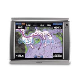
Put the power of Garmin’s next-generation marine navigator right at your fingertips with the GPSMAP 7015. This touchscreen chartplotter is the flagship in Garmin’s line of full-featured marine products. The GPSMAP 7015 comes standard with a worldwide, satellite-enhanced basemap as well as video-quality resolution on an impressive 15.5” (39.37 cm) XGA display. The GPSMAP 7015 also provides total system integration, allowing support for the addition of sonar, radar, weather and more. For additional enhanced features, you can add the optional BlueChart? g2 Vision? card.
The GPSMAP 7015 brings unprecedented speed to your vessel with Garmin G Motion? technology – the future of marine technology today. With blazing-fast map redraw and refresh rates, you’ll have near real-time data to guide you. Whether you’re in a crowded harbor or uncertain weather, you’ll have the confidence you need to navigate your surroundings with the GPSMAP 7015 as your guide. The GPSMAP 7015 also is compatible with an optional remote and computer mouse for added flexibility. And with a sleek and stylish design that was built to brave the elements, the GPSMAP 7015 looks great in any helm.
The GPSMAP 7015 features a worldwide basemap with high quality satellite images in place of more traditional maps. And for more detail, you easily can add maps with the SD? card slot without having to connect to a computer. The GPSMAP 7015’s high-speed processor draws maps quickly, and its simple intuitive interface makes navigating easy. In addition, the GPSMAP 7015 has support for PC input so it can be used to display presentations and computer applications. And to keep tabs on your engine room or other area of your boat, you can connect a live video feed with the GPSMAP 7015’s video input/output options. The GPSMAP 7015 also comes standard with a wide range of brightness options; from sunlight-readable to low-light conditions, you can adjust the setting to match your surroundings.
With the optional BlueChart g2 Vision SD card, you can add a whole new dimension of exceptional features to your chartplotter.
MarinerEye view and FishEye view provide you a 3-D perspective of map information, both above and below the waterline.High-resolution satellite images and aerial photographs help you orient yourself in unfamiliar areas.Auto Guidance technology searches through all relevant charts to create a route you can actually follow — one that avoids obstacles, shallow water, buoys and other obstructions.
The GPSMAP 7015 easily connects to your network, providing system integration so you can interface with additional MFDs and add remote sensors. Once connected, you can share information between the GPSMAP 7015 and other chartplotters on your boat. You also can add high-powered radar, sonar and XM satellite weather and radio to your system.
硬件和性能: | |
| Unit dimensions, WxHxD: | 15.5" x 11.8" x 5.9" (39.4 x 30.1 x 14.9 cm) |
| Display size, WxH: | 12" x 9", 15" diagonal (30.5 x 22.9 cm, 38.1 cm diagonal) |
| Display resolution, WxH: | 1024 x 768 pixels |
| Display type: | Touchscreen XGA display |
| Weight: | 17.4 lb (5.4 kg) |
| Battery: | none |
| Battery life: | none |
| Waterproof: | yes (IPX7) |
| High-sensitivity receiver: | yes |
| Antenna: | external |
| NMEA input/output: | NMEA 0183, NMEA 2000 |
地图和内存: | |
| Basemap: | yes |
| Preloaded maps: | no |
| Ability to add maps: | yes |
| Built-in memory: | none (cannot load maps to internal memory) |
| Accepts data cards: | SD? card slot (BlueChart g2 Vision cards sold separately) |
| Waypoints/favorites/locations: | 5,000 |
| Routes: | 100 |
| Track log: | 50,000 points |
特征: | |
| Garmin radar compatible: | yes |
| Garmin sonar compatible: | yes |
| Garmin Marine Network? compatible: | yes |
| Touchscreen: | yes |
| Supports AIS (tracks target ships' position): | yes |
| Supports DSC (displays position data from DSC capable VHF radio): | yes |
| Audible alarms: | yes |
| Tide tables: | yes |
| Hunt/fish calendar: | no |
| Sun and moon information: | yes |
| 3-D map view: | yes (with optional BlueChart g2 Vision card) |
| Auto Guidance: | yes (with optional BlueChart g2 Vision card) |
| XM WX Weather & Radio for U.S. & Canada compatible: | yes |
| Automatic routing (turn by turn routing on roads): | no |
| Voice prompts (e.g. "Turn right in 500 ft."): | no |
| Speaks street names (e.g. "Turn right ON ELM STREET in 500 ft."): | no |
| Headphone jack/audio line-out: | no |
| Audio/video input/output: | yes |
| Portable: | no |
| Automotive/motorcycle-friendly: | no |
| Additional: | Interface Inputs/Outputs: 4 NMEA 0183 inputs, 2 NMEA 0183 outputs; 4 video inputs for onboard cameras, 1 PC monitor video output, 1 PC monitor input |